
Proudly created with Wix.com
The Record Breaking Floating Bailey Bridge Across The Maas at Gennep.
Page one Page two here
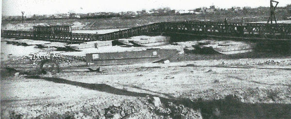
Photo of the bridge taken in late Febuary 1945 when the flood waters had subsided.

I left Normandy at the end of September 1944 having led a fine body of river men from D Day morning landing vital military vehicles and supplies by Rhino Ferry. Someone in War Office discovered that more men were drowned on D Day than were shot. So a decision was made to send me, a river man, to Second Army to assist the Chief Engineer in planning the crossing of waterways. They could not have known that on enlistment in 1939 I was a nineteen-year old fifth-year apprentice waterman. It was very interesting work and here I describe some of my time there.
The city of `s-Hertogenbosch (known in The Netherlands as Den Bosch) was liberated on 27th October 1944 after four years of occupation. Two days after the first tank arrived in the main square I was at City Hall welcomed by a large crowd among whom were children dressed in orange, a colour which had been forbidden by the Germans for four years. Temporarily on the staff of Brigadier “Ginger” Campbell, Chief Engineer, I wore on my sleeve the white shield with blue cross of Second Army as I went to collect valuable maps of the River Maas which had been hidden from the Germans by staff of the Rijkswaterstaat (Dutch State Waterways). When Nijmegen was liberated on the 17th September a Dutch waterways man, at great personal risk, joined our army a few days later. He was a degree engineer, Lieutenant Constant Lodewijk Marius Lambrechtsen Van Ritthem. The two of us were involved in planning “The Opposed Crossing of Water Obstacles”. The maps were invaluable as they gave spot heights of dykes and flood planes along the River Maas. Just what a bridge man needed.
From City Hall someone took me to the office of the Bevrachtings Commissie (a committee arranging the loading of river barges) where the newly liberated staff gave me the precious maps. It had taken four days to liberate Den Bosch and had cost the lives of 176 brave men of the 53rd Welsh Division. Heavy shelling had killed 36 citizens among whom was the brother of Luc Van Gent, a brave member of the underground now eighty-seven, who did so much to make my visits these last three years so rewarding. Luc was fighting with the underground resistance groups during the shelling when he learned that his fiancee Agnes had been wounded by shrapnel. I have had the pleasure of meeting this delightful lady.
Back at HQ at Geldrop Constant was delighted with the maps. It was an honour and pleasure to work with such a brave patriot who well knew that we risked capture when in no-mans-land where I would have been made a prisoner but he would probably have been tortured before being shot. We were busy during the next three months on a variety of tasks and rarely finished before midnight. Much time was spent studying aerial photographs,water levels and river approaches, as these would affect the initial assault and bridge design. Between Maastricht and Mook about eighty kilometers of the river Maas were either in German hands or abandoned in no-mans-land.
Three miles downstream from Maastricht we had a floating Bailey at Borgharen which was very busy during the night hours with troops moving up towards the German border near Sittard. Constant had warned that an attack by us on Roermond, where the Roer joined the Maas, was likely to result in dams of the Siegfried Line being blown to bring large areas of the Roer valley under a metre of water. Our attention concentrated on more attractive bridging areas downstream at Mook and Gennep. During Christmas 1944 we expected German “paras” to land behind our lines, but they did not come.
In the New Year there was a foot of snow everywhere and a decision was made to cross at Gennep where a long established ferry was serviced by good roads across the flood plane from dyke to riverside on each bank. Brigadier Campbell came to Constant on 30th January and asked him to predict the width of the river for the days following the 10th February, when the initial assault by the 51st Highlanders was to be made. Fortunately the snow in the area had begun to thaw and heavy rain was forecast. We knew that the enemy had damaged the outlets of the Schwammauel Dam to release extra water in the Roer valley and the Maas. With the Den Bosch maps at hand Constant convinced the Brig that the three-hundred-meter-wide river would be twelve hundred metres wide and, more importantly, there would be enough water over the flood plain to float pontoons.
I believed it would take some time to convince the Brig that the situation called for a record-breaking bridge three-quarters of a mile long, but four months of Constant’s reliable forecasts were enough for the Brig to forward the information to General Dempsey (Second Army Commander) with confidence. I well remember the Brig turning to his Second in Command, Colonel Otto Phibbs, saying “We must tell our sappers at Mook to build eighty-foot floating sections of Bailey until we tell them to stop“. He changed his mind as most of the bridge parts were not floated up from Mook but brought to the town square at St Antonis in 140 lorries prior to the assault.
On 5th February a photographic-reconnaissance Spitfire, flown by Canadian Flight Lieutenant Lightbody, one hundred feet up, took forward facing oblique photos every two seconds, of “our” bit of Maas and these showed enemy trenches waterlogged and the lock at nearby Sambeek already under water, much to my relief, for we did not have to worry about fluctuations in water levels through enemy activity. We had visited Sambeek in December after November floods had poured over the weir and scoured a by-pass round it, leaving no head of water and the weir gates ineffective.
The bridge was planned to cross exactly where the ferry entrances were, so that use could be made of the ferry approach roads as soon as the flood plain was “dry”. This would free nearly a thousand metres of Bailey for bridging the next main water obstacle, the Rhine. The assault was difficult and costly. Bridging began only after 46 men of the 51st Highland Division had given their lives (19 Black Watch, 17 Gordons, 4 Derbyshire Yeomanry, 3 Royal Engineers, 2 Royal Artillery and 1 The Kings Own). Work began on 12th February and the bridge was opened as a Class 40 Bridge (40 ton loads) on 20th February. It was 4008 ft., 1222 m. long; the longest floating Bailey of the war.
Dutch engineer Lt. Constant Lambrechtsen was the first to forecast the length needed so Brigadier Ginger Campbell, Chief Engineer Second Army always referred to this record-breaker as “Lambrechtsen Bridge”. That is good enough for me. One day someone will put up a memorial at the site to remind us of the genius of a very brave man.
Major Edwin (Ted) Hunt MVO. 12 June 2013